The Barrington Trail: Public Trails
Length: 3.0 miles one-way, less if you only do part
Difficulty: Easy to moderate
Location: Seavey Bridge Rd (off of Greenhill Rd), or BYA ball fields, or places in between (see map)
Activities: Hiking, XC skiing, snowshoeing, fishing. This is a walkers only trail with no wheeled vehicles allowed on most sections.
Parking: Parking area on Seavey Bridge Rd. or BYA ball fields near the ball fields on the right.
The Barrington Trail was formed by the town trails committee in 2001. It crosses both public and private lands, and can only continue to exist through the generosity of these landowners to allow the public to traverse their properties. Please be respectful. Except for a few short sections of the trail that are on paved public roads, motorized wheeled vehicles are not permitted on the Barrington Trail.
THE “BARRINGTON TRAIL”
Hiking and happiness go hand in hand (or foot in boot).”
Diane Spicer
The following private landowners have given permission for people to walk on their land and share in its beauty:
- Sherry Legere
- James Schulz
Please be respectful of the land, and thank these individuals should you see them. Their permission can be withdrawn if people abuse their property.
The Barrington Trails Committee began in 1999 as a part of the Town’s Natural Heritage Committee. Its first major project was to plan a trail that would go from one corner of the town to the other. That lofty goal has not been completed, but the Barrington Trail is part of that vision.
The trail was completed in 2001 and its first section was named after one of the Town’s leading citizens, Colonel John Barr. The trail starts at the intersection of Greenhill Road and Seavey Bridge Road, running from Greenhill Road, along the Isinglass River, through old farmland and woods, along a couple of paved roads, and ending up at the BYA ballfields on Smoke Street. It includes one of the most beautiful sections of the Isinglass River, with a view of Winkley Falls, once the site of two colonial mills.
Part of the trail runs through the Schulz/Legere property, which was permanently protected in 1991 by a conservation easement held by the town. This easement, which was donated by Jim and Ann Schulz, does not mandate public access, but the owners have generously allowed the trail to cross it.
In 2017 the Barr property, which contains the northernmost section of the trail, was permanently conserved via a conservation easement held by the Southeast Land Trust. This easement does allow for public access for hiking, hunting, fishing, cross country skiing, and nature observation.
If you have two cars available, drop off one at the ball fields and then start your walk from Greenhill Road. Of course, you can start your walk at the ball fields. Kiosks are planned to be placed at the entrances.

The 2001 Opening Ceremony for the Barrington Trail
Left to Right: Nancy Marden (Trail Committee), Margaret Watkins (National Park Service), Col. John Barr (Honored Barrington citizen), Jim Schulz and Denis Beaulieu (Trail Committee)
The Barrington Trail is marked with white blazes; the Loop Trail has yellow blazes.
Directions to the Barrington Trail Head
North end: From the Route 125 and Route 9 intersection in center Barrington, go north on Route 125 toward Rochester a little over a mile (see map at beginning of this book). Turn left at the stoplight onto Greenhill Road. Go about a mile until you see the bridge that crosses the Isinglass River. Immediately before the bridge, turn left onto Seavey Bridge Road (a dirt road) and park at the parking area about two hundred feet up the road on the right. Blazes in white and directional arrows mark the route of the trail.
South end: From the Route 125 and Route 9 intersection go west on Route 9 about ¾ mile, then go right on to Smoke St. After 0.9 miles keep left (still Smoke St.) then go another 0.4 miles and turn right into the BYA fields. Turn right again and continue to the parking area at the end. Walk straight back (away from Smoke Street), with the ball fields on your left and the sand pits on your right. When you come to the tree line, you should see a Barrington Trail sign. Note: on Saturday mornings in spring and early summer, the area can be very busy. Stay a while, buy a hot dog, and watch a game!
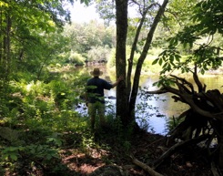
Trail Description and Directions from the North: Take the trail into the woods and head down toward the Isinglass river. Follow the white blazes. Except during very dry periods, there are beautiful rapids on this section of the river, which is a favorite place to fish. Eventually you will come to a small waterfall, Winkley Falls. This is the site of two colonial mills, one on either side of the river bank. You can still see some of the stonework from the mill on the far side. As you go farther up river, the rapids disappear and you enter a more tranquil portion of the river. Often there are ducks, herons, etc.
The trail goes along the river for about ¾ mile, then turns sharply left into the woods. There is a directional arrow here. (At this turning point, a trail along the river continues, but it is not part of the Barrington Trail). After turning and climbing past some big shagbark hickory trees, you will come out on the Class 6 (unmaintained) portion of Seavey Bridge Road, which you began on. If you just want to do the a short loop, turn left on Seavey Bridge Road and a short walk past some houses will return you to the start.
To continue on the Barrington Trail turn right onto Seavey Bridge road. In a few hundred feet on the left is a big vernal pool that usually dries up in late summer. Vernal pools are temporary pools of water formed by the collection of rainwater or run-off in a depression of the land. They are ecologically very important, serving as nurseries for most frogs and salamanders.
Be sure to notice any time of the year the beautiful ferns growing on the big boulders beside the pool. These small ferns, commonly known as rock ferns, are green even in the coldest weather.
Soon thereafter the trail (road) crosses a depression or ditch, with a field through the trees on your left. A couple hundred feet later, the trail turns sharply left off of the road and into the woods (directional arrow sign). Before turning, look right and notice the big, beautiful “Swedish” red barn on your right that dates back to the 1930s.
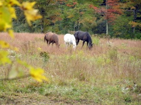
Immediately after turning, the trail passes to the right of an old cemetery. Check out some of the headstones. Shortly thereafter you come to Scruton Pond Road (paved). Turn right and walk about 900 feet, past the intersection with Brewster Road and a horse pasture, then turn left before you reach a pond.
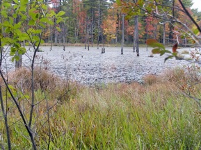
Reentering the woods, you will see on your right (through the bushes and trees) this beautiful beaver pond. The trail is flat for a short time and then rises gradually. Notice as you walk through the woods in this area the magnificent big, straight white pine trees that have somehow eluded the logger’s saw.
When the trail reaches the top of the small hill, there is a short path to a “lookout” where there is an excellent view of the pond. For many years the trees in this pond have been home to Great Blue Herons. You can see several of their nests in the dead pine trees standing in the middle of the pond.
The Great Blue is the largest heron in North America, standing 3 to 4 feet tall and with a wing span of almost 6 feet. It is often seen wading in shallow water looking for food — fish, frogs, crayfish, and other inhabitants of ponds, streams, and wetlands.
Great Blues return from the South very early in the spring. You are likely to see them starting late March until early October. They are very shy birds. Be quiet near their nests or they may be abandoned. Time it right (generally May), and you may see the parents feeding their chicks.
Other creatures you should look for from the lookout are ducks, Canada geese, swallows, turtles, muskrats, otters, and hawks.
Leaving the lookout, the trail circles around the horse pasture and emerges onto Brewster Road (paved). A pitch pine near the trail is tied with another as the largest in Strafford County.
When you reach Brewster road turn right and walk about 1000 ft to where the marked trail begins again at a dirt road turning in to the right. After turning off of the pavement, the trail crosses over water and wetlands, then immediately turns sharply left at a clearing.
NOTE: At the time of this writing, the property directly off of Brewster is in the process of being acquired by the Southeast Land Trust (SELT). SELT will likely be developing trails on this property aside from the Barrington Trail
A few hundred yards after you turn left the trail turns right again and at this point passes (on the left) a short path to a beaver dam. The dam is often hidden by tall grasses, but you will usually hear water leaking out of it.
The trail then climbs very briefly, flattens out, bends to the right, then continues climbing and soon reaches the ridge.
Follow the white blazes and you will come to an intersection where the Barrington Trail turns sharply left. (At this time the trail going right is not for public use). After about 100 yards, the trail enters land owned by the town. At this point, the alternate Loop Trail (see below) goes right and is marked by yellow blazes. The Loop Trail rejoins the Barrington Trail farther to the south.
The Barrington Trail (left), soon turns right and climbs a steep but short hill, goes over a rock surface, and then goes down again; there is an short alternative section that avoids a very steep part here. The trail continues generally south and is eventually rejoined by the Loop Trail. About 200 yards beyond this junction, the trail turns sharply right, passes through a wet spot with a bog bridge (boards), and then turns right again. [Note: At this point you will see an old section of the trail that has been closed, with passage barred by brush across the trail. It is for equestrian use.] The Barrington Trail soon emerges from the woods near the town mulch pile and sand pits, near the ball fields. This is the end of the trail.
The Loop Trail: Public Trails
Length: 3.0 miles one-way, less if you only do part
Difficulty: Easy to moderate
Location: From the ball fields, the Barrington Trail is marked with white blazes and arrow signs on tree trunks.
THE LOOP TRAIL
It enters the woods and immediately turns right, working its way along the bordering wetlands. Farther on it turns sharply left and crosses a wet area with a bog bridge (boards) to walk on.
The trail eventually makes another sharp left. Then, after about 200 yards, you will see the Loop Trail going off to the left. It is marked with yellow blazes.
As you walk along the Loop Trail, you will notice a number of large and beautiful rock outcroppings on your right. As the trail goes slowly downhill, you will see a large open wet area that in summer is filled with tall grass. This wet area was created by a large beaver dam to the northwest (which you cannot see). The dam is very old and not maintained by beavers at this time. As a result, while the dam is still there, it leaks badly — resulting in wetlands rather than a pond.
Beavers are still in the area, however, building and maintaining a number of other dams. Beavers have big flat tails that are used to warn other beavers of enemies by slapping them on the water. Its other big use is for packing mud into their dams. Beavers also have very large teeth which they use to chew through tree trunks until the trees fall down. They eat the tree bark (their main food source) and use the “debarked” branches, small tree trunks, stones, and mud to build their dams.
Eventually the Loop Trail rejoins the Barrington Trail (see Barrington trail description). If you go right, you continue on a loop that returns to the ball fields and parking lot – a total trip of about 0.9 miles. If you go left, you will be walking on the Barrington Trail that eventually goes to Brewster Road and beyond.
Original text Copyright 2008 James H. Schulz, updated and revised.