Newhall Property: Public Trails
Newhall Trail • Barrington, NH • Public Trails
Text Copyright 2008 James H. Schulz, Portsmouth, NH
This description is taken from a booklet describing certain trails in Barrington that was last published in 2008. The author of the guide was approached in October, 2010 for permission to put its contents on the Web site for the Town of Barrington. Readers and users of the guide should keep in mind that the nature and condition of the trails discussed will in some cases be different from the description in the booklet. The information in the guide was correct at the time of initial publication. However, the author and the Town of Barrington take no responsibility for trail-walking problems arising from changes since its initial publication.
Another hiking trail open to the public that is not owned by the town is the Newhall Trail. This trail is on land put into conservation by the Newhall family. Families who want to preserve special land forever, can create a “conservation easement.” Under this legal arrangement, the land owners keep ownership and control of the land, but no new housing or businesses can ever be built on it. While an owner placing land into easement can retain the right to prohibit or restrict the public from walking, riding, or hunting on the land, many easements allow a certain amount of public access. In the case of the Newhall property, the conservation land is open to the public at all times of the year for hiking and cross-country skiing. Use of wheeled vehicles is prohibited. Hunting is by permission of the owner.
Note that in the spring parts of the trail are very wet, with depressions in the trail sometimes filling with water.
Directions to the Newhall Trail: The trail head is on Wood Road. From the intersection of Wood Road (now Merry Hill Rd.) and France Road (near Swains Lake), go 1.6 miles on Wood (Merry Hill) Road. The trail head is on the right side of the road at the intersection of three roads: Wood (Merry Hill), Alwood (now Hemlock), and Partridge Roads. There is no formal parking; park on the roadside.
To find the trail head, look for the biggest rock among those bordering the land. Just beyond that big rock you will see the sign for the trail. (At the time of writing, there was a plan to move the boulders blocking the entrance to the trail and replace them with a gate.)
Alternate route: You can also reach the Newhall conservation land by traveling on Route 4. When going west on Route 4, turn right onto Merry Hill Road and go less than a mile to the intersection of the three roads. Note: Merry Hill Road changes to Wood Road when it crosses the boundary into Barrington.
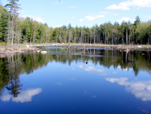
On this land is a small but beautiful natural pond* fed by a (usually) rushing brook. The trail itself is an old logging road most of the way. It is relatively short (less than a mile) and easy to walk, with no climbing required.
The main trail is essentially a loop. Shortly after starting down the trail, it bends to the left and you then see a sign for the Pond Trail. This trail goes down to the pond. Note the Great Blue Heron nests on top of dead trees in the water (see the discussion of the herons in trail #1). The Pond Trail goes along the pond and ends up near an old logging bridge crossing a rushing stream (see options discussed below).
If you do not take the Pond Trail, you continue on the main trail. After a short way, note the huge pine tree on the right side of the trail. It is unusual both because of size and the complicated branching of its limbs.
Further on you will see “Monument Rock,” a huge boulder about 100 feet off the trail to the left. A little further on, watch for “Pyramid Rock” on the right side of the trail. And still further on, note the gigantic Hemlock tree just off the trail on your right.
The main trail eventually comes to an open area with the farm house and sheds off to your left. Walking on the land to your left is prohibited. Instead, follow the trail signs and make a sharp right.
After a while, you will come to a fork in the trail. The main trail bends left. The right fork goes down to the stream and the logging bridge crossing it. Here you will find the other entrance to the Pond Trail. Thus, at this point you could start walk back to the car by making a loop on either the main or pond trail, depending on which you came in on.
For those who go down to the stream, caution is required on the old rotting bridge. Crossing the bridge, you will immediately see the Brook Trail going off to the left. This short alternate trail goes along the brook, crosses, and continues through woods till it rejoins the main trail. Note that this trail requires you to cross the stream to get back to the main trail. There is no bridge at this crossing, just some big stones. Therefore, you may not be able to cross the stream easily or safely during periods of high water (especially in the spring).
At the fork, if you stay on the main trail, it continues in a loop. Eventually it returns to the open space area, with the farmhouse now on the right. From the fork to this point, there are many wet spots in spring or after periods of heavy rail. You be forced to walk off the trail for brief distances. Upon reaching the open space, continue straight and return to the trail head and your car.
* Note: the beavers left the property in about 2008, and their dam has since deteriorated. The pond has thus largely drained, and is now a large wetland supporting a different variety of wildlife than before.
Click Maps below for Printable-Downloadable Versions.